
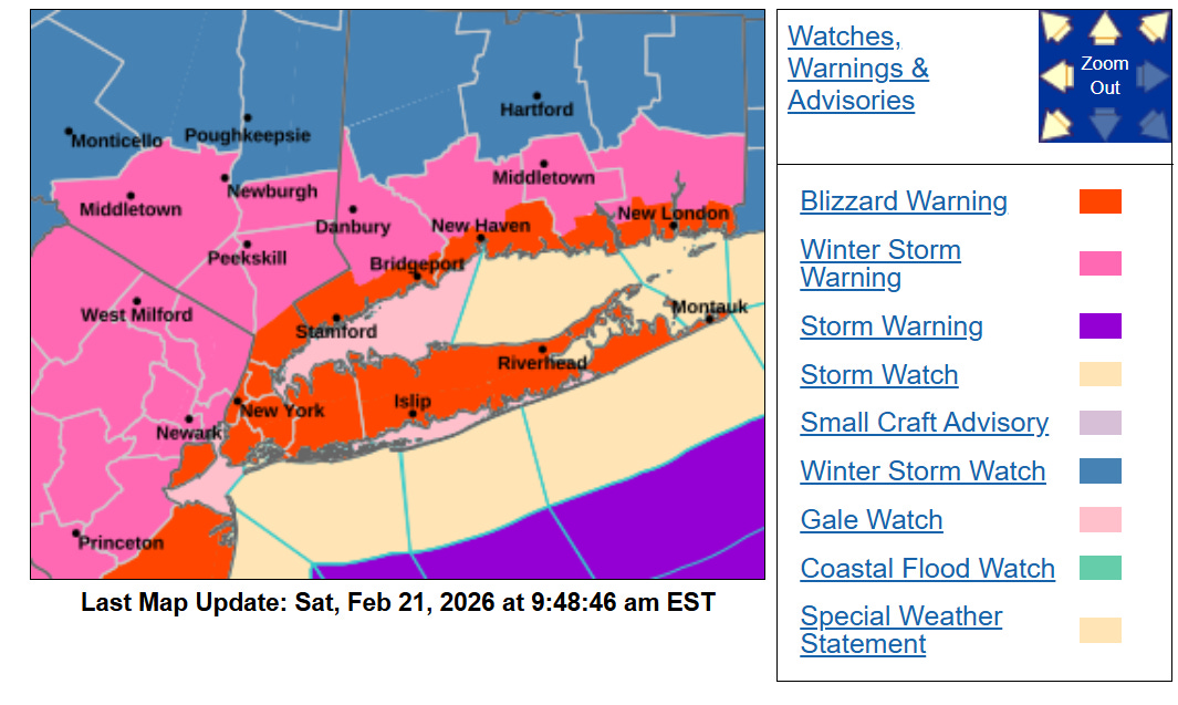
- National Weather Service issued first Blizzard Warning for the five boroughs in eight years
- Effective 1:00 PM EST Sunday February 22 through 6:00 PM EST Monday February 23 2026
- Combines heavy snowfall rates of 1-3 inches per hour with sustained winds of 25-35 mph

N.Y. weather: What is a blizzard warning and what does it mean for NYC amid major snow storm? - silive.com
| Borough | Snow Accumulation | Wind Gusts |
|---|---|---|
| Manhattan | 12-17 inches | 45-55 mph |
| Brooklyn/Queens | 13-18 inches | 45-55 mph |
| Bronx | 12-16 inches | 45-55 mph |
| Staten Island | 14-20 inches | 45-55 mph |
NWS Issues Winter Storm Warning for Northeast
- Winter Storm Warnings cover interior southern Connecticut Lower Hudson Valley and southern Westchester
- Alerts affect more than 15 million people across New York New Jersey and Connecticut
- One of the most significant nor’easters for the region in nearly a decade
February 21, 2026 Blockbuster Blizzard Warning
| Warning Type | Primary Areas | Duration |
|---|---|---|
| Blizzard | NYC Long Island Coastal CT | Sun 1 PM – Mon 6 PM |
| Winter Storm | Inland Northeast | Sun morning – Mon evening |
Heavy Snow Expected Across New York Region
- Widespread totals of 10-20 inches with locally higher amounts near coast
- Peak rates of 2+ inches per hour possible late Sunday night into Monday morning
- Wet heavy snow transitions to drier snow by Monday increasing tree and power line risks

N.Y. weather: These 8 maps show latest snowfall forecast for NYC from major nor'easter - silive.com
| Region | Most Likely Total | Maximum Potential |
|---|---|---|
| New York City Metro | 13-18 inches | 22 inches |
| Long Island | 15-20 inches | 24 inches |
| Northeast New Jersey | 12-18 inches | 20 inches |
| Southern Connecticut | 11-15 inches | 18 inches |
Coastal Flood Watch Issued for New Jersey
- Watch in effect for Monmouth Ocean Atlantic and Cape May counties
- Moderate flooding with 1-3 feet inundation possible during high tides
- New Jersey Governor declared statewide State of Emergency effective noon Sunday
| Tide Cycle | Expected Inundation | Impact Level |
|---|---|---|
| Sunday Night | 1.5-3 feet | Moderate-Major |
| Monday Morning | 1-2 feet | Moderate |
Blizzard Conditions Forecast for NYC Area Sunday
- Whiteout conditions with visibility frequently ¼ mile or less Sunday night through Monday morning
- Strongest winds and heaviest snow between 10 PM Sunday and 10 AM Monday
- Travel expected to become extremely hazardous or impossible Monday morning
- Complete essential travel and preparations before Sunday afternoon
- Stock 72-hour emergency supplies including water food medications and batteries
- Monitor official NWS and local emergency management updates for closures

Comments